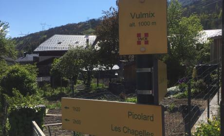
Tot 26 april op de pistes

LIVE

woensdag 12 maart Bijgewerkt op 03-12-2025 om 8:06

sneeuw
  • sneeuw :
    • 5 cm hoog. op 1600m
    • 4 cm hoog. op 3200m
  • Sneeuwkwaliteit :
    • DOUCE
  • 260 cm hoog. op 1600m
    • DOUCE
LIVE

woensdag 12 maart Bijgewerkt op 03-12-2025 om 8:06

Schrijf je in voor onze nieuwsbrief om niets te missen van les Arcs!

sneeuw
  • sneeuw :
    • 45 cm hoog. op 1600m
    • 260 cm hoog. op 3200m
  • Sneeuwkwaliteit :
    • DOUCE
  • 260 cm hoog. op 3200m
    • DOUCE
Boek uw verblijf Koop jeski- en wandelpas Vinduw route

Voetgangersroutes in Les Arcs

Of u nu een dagjeswandelaar bent of een ervaren bergwandelaar, of zelfs op sneeuwschoenen loopt, het is met veel plezier en sereniteit dat u zich zult verwonderen over de schoonheid van de natuur en de weelde van de landschappen die u omringen.

Ontdek de 20 km aangegeven paden en maak van uw dag wandelen in Les Arcs een onvergetelijke ervaring! Adembenemend uitzicht en herinneringen in overvloed!

Wij bieden paden en wandelingen aan vanaf elk dorp in Les Arcs en Bourg Saint Maurice.

Tip: De PASS PIÉTON + geeft u toegang tot liften en activiteiten in het resort.

Plattegrond Station

Vukmix : the fort trail

Bourg St Maurice, Place de la Gare

Trail through forest and meadows with a beautiful view of the valley and surrounding mountains. PLEASE NOTE: HUNTING SEASON OPEN FROM 10/09 TO 28/01

Wandelaars
3.9 km 261m D+ 143m D-

Durée : 1h20
Altitude moyenne : 916m
Altitude maximum : 1060m
Type de parcours : Boucle

Télécharger le tracé

Descriptif

From the train station take the “Avenue de la Gare” turn left into the “Grande rue” and follow all the way to the church. Continue straight on to the “Rue Jean Monnet” as far as “La Residence” and turn right. Cross the bridge and descend on the left for 200m towards “Le Reverset”. Take the path on the right and follow the signs to the village of Vulmix. Take a tour of the famous Saint Grat chapel or the Fort. (Enquiries at tourist office.)

Période d’ouverture

Het hele jaar.


Onder voorbehoud van goede sneeuwcondities en goede weersomstandigheden.

Balisage

L'itinéraire est balisé.

Précisions balisage

The trail is indicated by yellow signs with a green inscription.


You can also find yellow rectangles painted on stones or ponds.

← Terug naar activiteiten